**POPCORN POST** I promised I’d warn you to grab snacks for longer reads 😊. You’ll probably want the share size bag and comfy pajamas 'cause we’re about to find out if there’s a character limit for a single post. I thought about breaking Omaha beach into multiple posts but… fortune favors the bold!! I did include section headers so you can take breaks and easily find your place again. Here we go!
Bayeux
Bayeux was not my first stop in France, but it was the main reason I visited. It was the closest larger town to the Normandy beaches, I could reach it for cheap by train, and nearly all the guided tours departed from there. I booked a full-day tour of the American beaches with the Overlord Tour company for 17 Jun. The tour started at 8:20 a.m. and the first half of the day was focused on Omaha Beach. I arrived by train about an hour before the tour began; I was starving and the town was mostly still sleeping. I found an open café called La Grande Manger just around the corner from the tour meeting point and ate breakfast there. Standard eggs, bacon, croissant, & coffee. I noticed I was close to the town’s main cathedral. After breakfast I strolled one block over to briefly check it out before heading to the tour meeting point.
There were several tour groups casually mingling at the rendezvous. The tour vans and guides arrived promptly at 8:20 a.m. The guides sorted us into our assigned groups for the day and introduced themselves. My group consisted of a couple from Australia, two men from the Netherlands, and two other American men from California and Connecticut. Our guide was Guillaume (pronounced Ghee-yam… French version of the name William), a slender, soft-spoken, native Norman whose parents both remembered WWII and had told him many stories about it growing up. The seven of us loaded into a 9-passenger van and headed north towards the coastline.
Along the way, Guillaume explained that Bayeux was an anomalous town in the region since it suffered almost no damage during the war. The Nazis used Bayeux exclusively for leisure and recreation (to include a brothel or two), so there were no armed combat forces inside the city limits. As a result, the Allies had no reason to bomb Bayeux. On D-Day, it was the first location abandoned by the Nazis because they all rushed off to their posts once they realized an attack was underway. He also explained the Atlantic Wall and mentioned Hitler had planned to build 15,000 armored gun positions along the coast from western France to northern Norway. By the time the Allies executed their attack in June 1944, Hitler only had 10,000 guns placed along the 2,500-mile stretch of coastline. Hitler tried to expedite the installation of coastal strong points after December 1941 because he knew the U.S. would enter the war after Japan attacked Pearl Harbor. The remnants of a coastal gun battery at Longues-sur-Mer was our first stop of the day.
Longues-sur-Mer
We parked next to a field and walked to a hilltop where four gun bunkers (casemates) were built to overlook the English Channel from a little over 1/4 mile inland. The beach was barely visible through the morning mist (3/8ths of a statute mile with fog… if we’re being technically accurate for a weather observation, go go gadget nerd goggles!). Guillaume explained this coastal battery was manned by 184 German soldiers. The first casemate was severely cracked. The gun inside was destroyed into four visible pieces. The bracket for the gun was still bolted to the casemate floor. The main mechanism and base of the barrel lay off the front left of the casemate in tall grass. A 4-foot mid-section of the barrel was laying to the front right of the casemate. The 2-foot tip of the barrel was across the gravel road that ran directly in front of the casemate. Both severed barrel pieces were about three-quarters buried simply due to time. The second casemate had partial damage; one of the rear side rooms had a collapsed roof. The third and fourth casemates were intact, with the third gun barrel still angled upward as if ready to fire at Allied boats. All the guns had battle damage where large Allied naval rounds had managed to pierce the gun’s front armor or sneak into the narrow front openings of the casemate. Other quick facts about this battery and the surrounding area:
Guns were modified 155-mm caliber naval artillery with a range of 12 miles.
Concrete casemates were rated to withstand the impact of 1,000-lb munitions.
Shells weighed 95 pounds and took two soldiers to assemble. It took eight soldiers to operate one gun, and they could turn a max firing rate of 6-8 rounds per minute, depending on the efficiency and stamina of the crew.
Made predominately by a French involuntary labor force.
Chips in the sides of the casemates were deliberately made so the Nazis could stuff foliage in them to camouflage the casemate’s concrete and man-made silhouette. There were also rebar loops sticking out of the top so they could secure camo netting to the tops of the casemates.
There were 500 Allied ships in the vicinity of this battery, predominately headed for Gold beach to the east of it. However, the battery sank zero vessels because Allied bombing had cut the communications line to the Nazi’s forward observing post.
Gold beach, specifically the town of Arromanches, was also the site of one of the Mulberry harbors (mobile port) the Allies brought across the channel with them. The other was further west on Omaha beach. However, the Mulberry harbor at Omaha was destroyed between 19-23 Jun when the “storm of the century” ripped through the channel. The Allies actually cannibalized parts from the Omaha harbor to repair the minor damage to the Gold harbor. Arromanches became the primary port until the Allies were able to secure and repair the deep-water port at Cherbourg (roughly early July 1944).
Area is littered with smaller personnel bunkers and defensive fighting positions.
Colleville-sur-Mer
After everyone was done looking at the coastal battery, we piled back into the van and continued west along the coast to our second stop of the day, Colleville-sur-Mer. Colleville is one of three main towns in the Omaha sector. Here we stood on the beach while Guillaume opened a large book filled with maps and photos to orient us and visually supplement his explanations. He outlined general features of the beach and its German defenses:
Armed with 15 strong points. 2x 88-mm guns, 2x 76-mm guns, and 10x machine gun emplacements capable of firing 20 rounds per second.
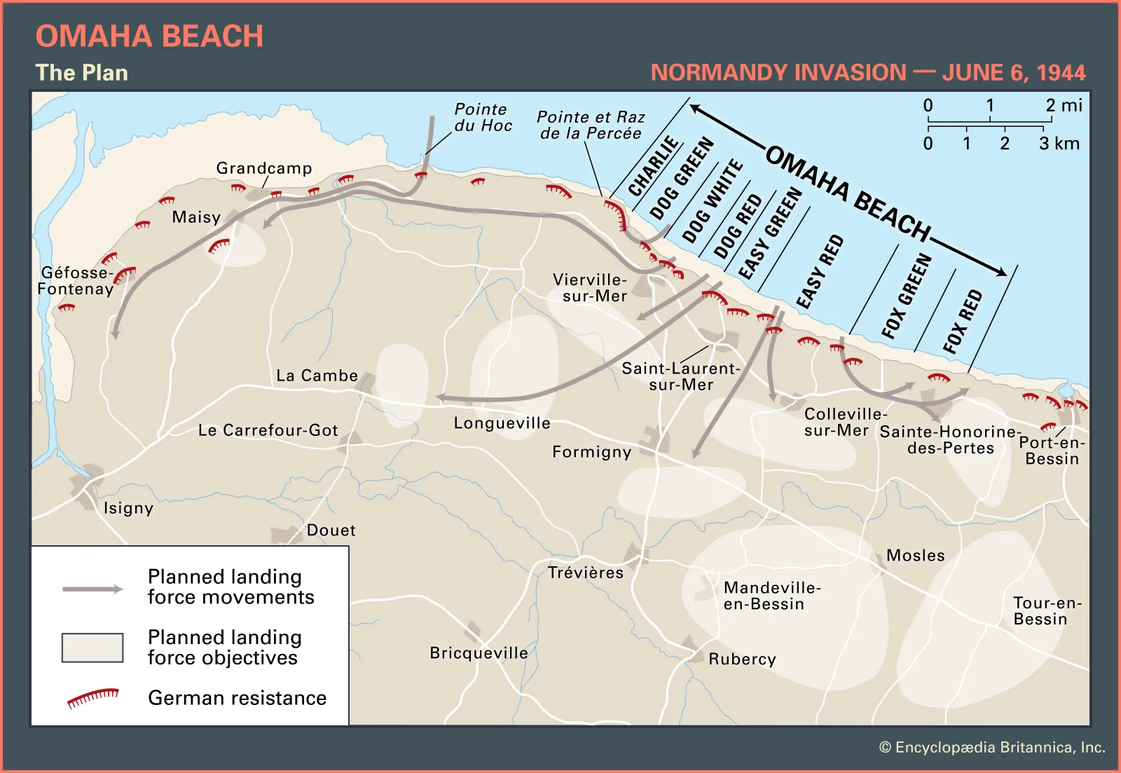
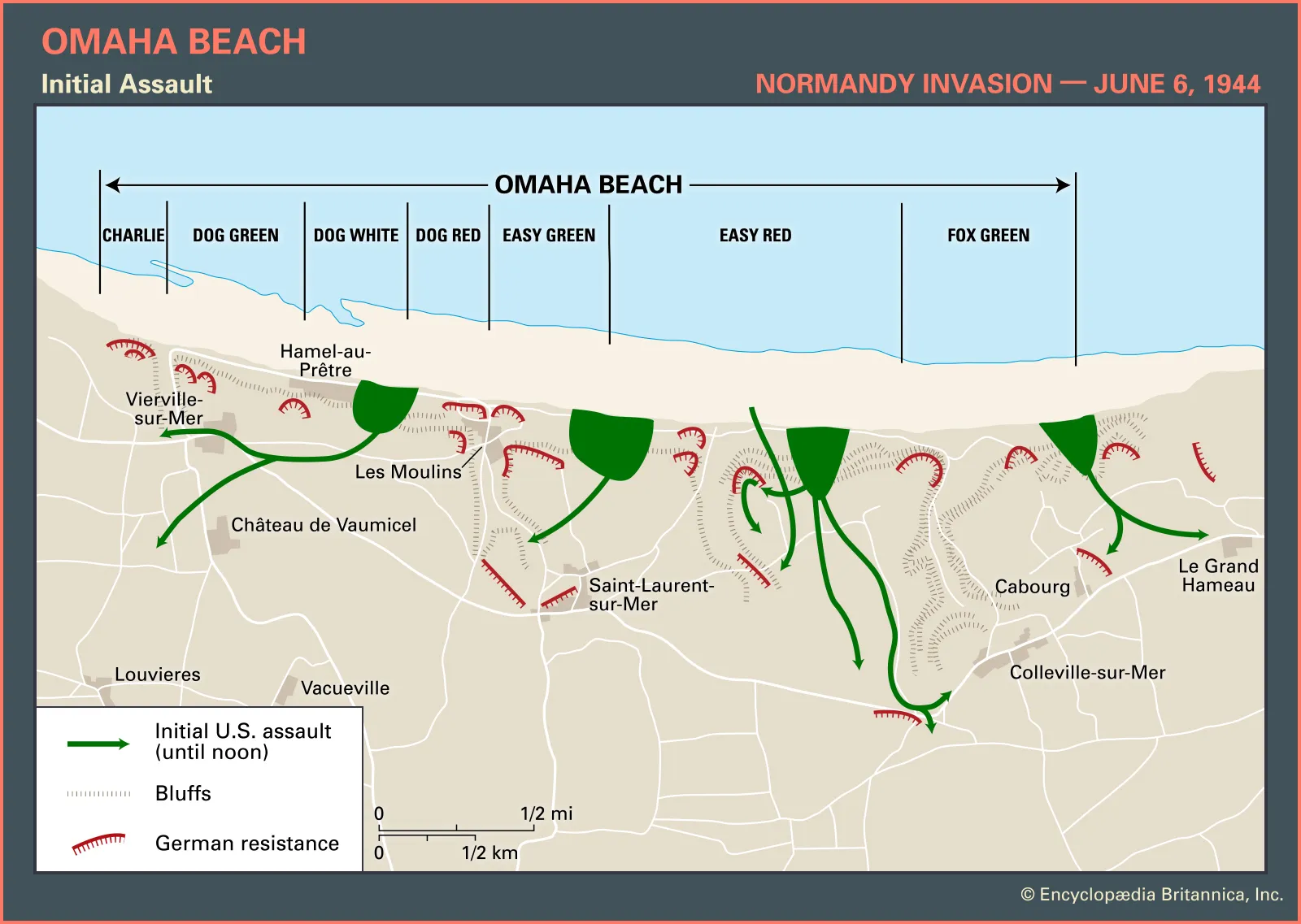
There were five natural exit roads called draws: D-1/Vierville, D-3/Les Moulins, E-1/St-Laurent, E-3/Colleville, and F-1/Number 5. All were fortified by German strongpoints, only one was paved. The objective of the initial assault (the first two waves) was to reach and clear all five draws within the first three hours of landing. The end-of-day objective in the Omaha sector was to have the town of Isigny under American control (see Normandy 1 post). Spoiler alert, neither of these objectives were achieved.
Omaha is a natural semi-circle shape. The Nazis used this to turn the entire beach into a massive and highly-lethal field of crossfire. Guillaume drew a diagram of this concept in the sand.
The distance between high and low tides is 400 yards (almost a 1/4 mile).
There were a variety of obstacles: hedgehogs (crossed steel beams), Belgian gates, mines mounted on stakes and tripods, etc. Average density of obstacles was one every five yards. All obstacles were covered by high tide. This forced the Allies to land during low tide; it added 400 yards of ground they had to cover, but ensured they didn’t sink every vessel they deployed on D-Day.
Omaha had seven sub-sectors; the two main ones we discussed were Easy Red and Fox Green.
1st Division and 29th Division were supposed to land on the west and east sides of the beach, respectively. However, all the units got mixed up in the chaos of the landing.
They tried to land amphibious tanks (they had an inflatable skirt, like a hover craft) on Omaha. These tested well in calm waters in the UK but couldn’t handle the 6-foot waves the landing force faced on D-Day. Only 5 of 32 tanks made it ashore… the other 27 sank.
Officers on landing craft were placed in front and were predominately the first to die, leaving units without leaders. This contributed to the chaos, difficulty, and higher casualty rate the Allies had at Omaha. Additionally, Omaha had the most landing craft drift off target due to stronger-than-predicted currents.
There is a rock memorial on Omaha near Colleville-sur-Mer where several medics sheltered and treated casualties on the beach.
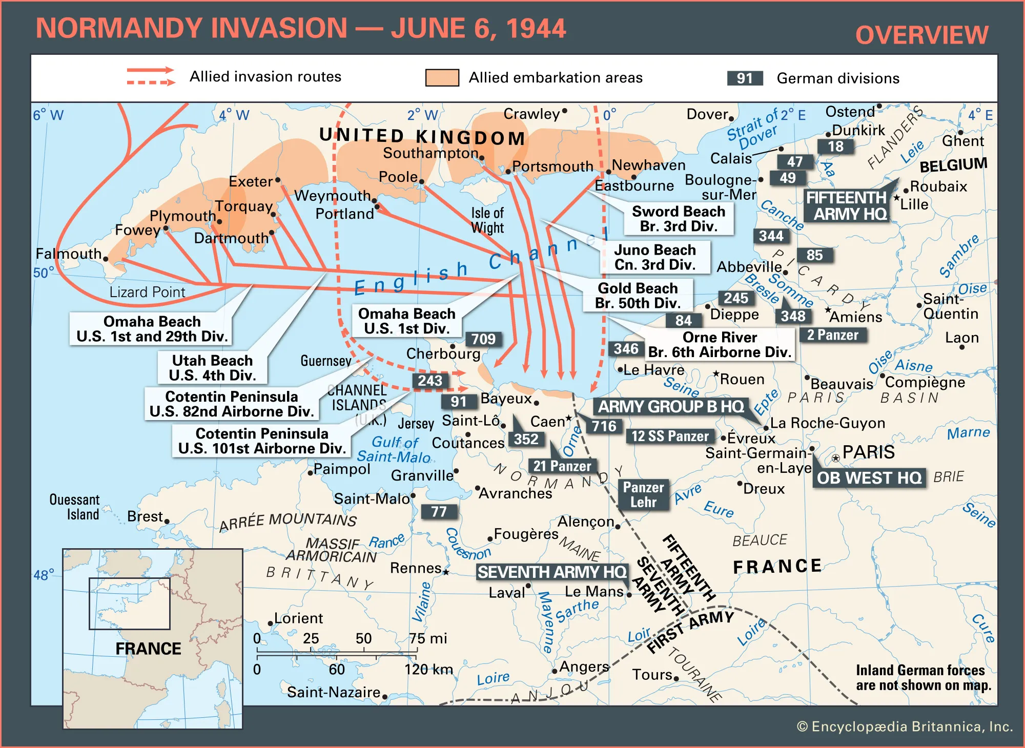
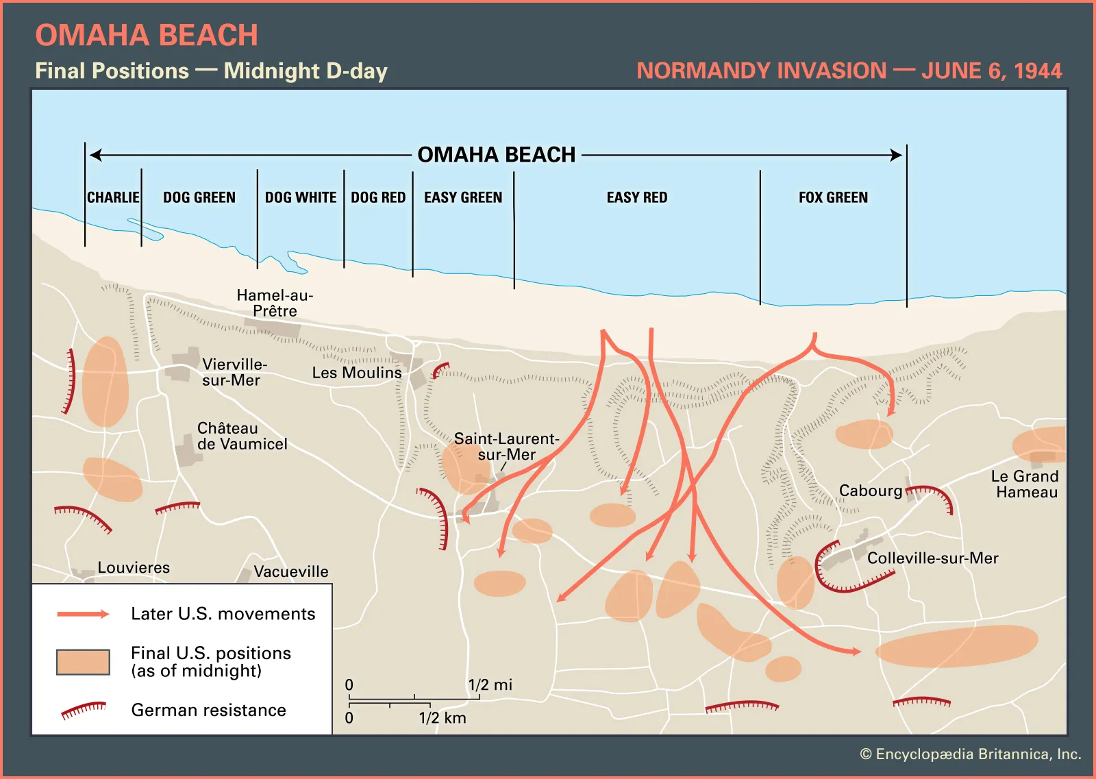
Guillaume also gave us a quick run-down of events on Omaha beach during D-Day. I’ve supplemented his timeline with other interesting points in time and pieces of info that loosely tie into my grandpa’s memoir (maps of most of this below):
0430 – Soldiers board landing craft and exit the naval rally point in the channel known as Piccadilly Circus.
0530 – Air support arrives to soften/destroy German strong points. Low cloud cover and poor visibility prevent accurate targeting and most munitions land too far inland.
0600 – Naval support arrives and ship batteries open fire, to include the Battleship USS Texas (my grandpa crossed the Atlantic with this ship in his convoy and it was his birth state). USS Texas delivers 225 shells onto the beach over the next half hour. Naval munitions also generally land too far inland to affect Nazi strongpoints. Now 1,000 German soldiers are wide awake, at arms, and ready to return fire.
0630 – First wave lands on the beach, comprised of the five tanks that didn’t sink and 1,500 men on 50 landing craft. As Americans wade to shore, Germans wait until water is knee-deep to open fire. All vital parts of American soldiers are exposed, but their mobility is still limited. There are 90 Allied casualties in the first wave (19 of them are Bedford Boys... more on this in the Vierville section). The USS Texas redirects its fire, now targeting German strong points and movement on top of Pointe du Hoc.
0700 – Second wave lands, another 1,500 men painstakingly push ashore. Pandemonium firmly sets in as casualties mount--most of them unit leaders--and units try to simultaneously figure out: 1) where they are versus where they're supposed to be, 2) who is in charge, 3) what units are next to them, 4) effectively engage the enemy, and 5) advance toward their objectives.
0900 – German strong points defending the eastern-most draw are knocked out and Allies reach the Number 5 Draw. Americans also reach the Les Moulins Draw, but are still fighting the defending strong points. Nazis report back to German High Command that they can repel the Allied assault (but lots more were coming). After General Omar Bradley, Commander of the First Army, gets news of the high casualties at Omaha, he has to decide… leave 3,000 soldiers stranded on the beach or carry on the operation. Bradley chooses to carry on, but delays the third and fourth waves to give the Allies time to adjust their plans and better organize.
1030 – Americans reach St-Laurent Draw but continue fighting strong points.
1130 – German strong points defending the St-Laurent Draw are knocked out.
1200 – Point du Hoc observation bunker is under American control. Americans reach the Colleville Draw, but continue to fight Wn-62, the largest (and most famous) German strong point. Still no Americans at the Vierville Draw. Germans continue to use it to push limited reinforcements into the area. While Americans have reached the other four draws, only the Number 5 Draw is actually clear and useable by noon. With no real exits, the Allies are increasingly restricted with where they can put all the equipment and supplies that are beginning to pile up and they are sitting with no cover on the beach head.
1300 – German strong points defending the Vierville Draw are knocked out by the Navy. However, German reinforcements that funneled down the draw for the first six hours of the assault are still preventing American forces from reaching the draw.
1500 – Wn-62 is finally knocked out and under American control.
1700 – Naval artillery destroys the steeple of the St-Laurent church because it's being used by German snipers.
1900 – Naval artillery destroys the steeple of the Vierville church because it's being used by German artillery forward observers.
2100 – Americans finally reach the Vierville Draw just after sunset, roughly 12 hours behind schedule.
2400 – 34,200 Allied troops are on shore after 23 offensive waves. 4,415 casualties (12.9%), 1,200 killed or missing in action (3.5%).
Grandpa's Landing on Omaha
All this information, plus standing on the beach and reflecting for a bit, really had me wondering where on Omaha my grandfather landed and exited when he arrived on 25 June 1944. While it’s impossible to say for certain, I did do some additional digging. Clue #1: He distinctly remembered having to “crawl up a steep cliff that seemed to be about a hundred feet tall.” The west end of the beach has the higher cliff faces that are 100-110 feet high. This narrows it to Charlie, Dog, or Easy sectors. Clue #2: My grandfather described “walking in about 5 miles” from the beach to their initial airfield. After the 48th Fighter Group moved their whole unit across the channel, they initially operated at an Advanced Landing Ground (ALG, it’s a mobile airfield) near Deux Jumeaux. The Allies had a coding system for their ALGs. ALGs in France were given an “A” prefix and then uniquely numbered. The hastily-built airfield near Deux Jumeaux was known as ALG A-4. It was located in an agricultural field west of the township at latitude 49.347778, longitude: -0.98055634.
As the crow flies, ALG A-4 was 4.1 miles southwest from the Vierville Draw, 4.8 miles southwest from the Les Moulins Draw, and 5.4 miles west-southwest from the Saint-Laurent Draw. Given these distances and accounting for the winding of roads, I feel very comfortable saying he landed somewhere in the Charlie, Dog Green, or Dog White sectors and most likely exited the beach using the Vierville Draw. The other sectors and draws were a bit too far from ALG A-4 to make sense. As a sanity check, I entered a walking route into Google Maps from the Vierville Draw opening on Dog Green to the ALG A-4 area; it came up as a 5.5-mile route with a transit time of 1 hour and 45 minutes. As my grandpa used to say, “good enough for government work!”
American Memorial Cemetery
After spending time on the Colleville area of the beach, we proceeded to our third stop, the American Memorial Cemetery. A portion of the cemetery overlooks Omaha beach. This is essentially the vantage point the Germans had on this segment of the beach. The cemetery was specifically designed to resemble Arlington National Cemetery so that it looked and felt as close to home as possible. Having been to Arlington, I’ll say the design concept was overwhelmingly achieved. There is a large memorial at the front, a medium-sized reflecting pool and small chapel in the middle, and some guardian-like statues at the back. The layout parallels the beach below it. The main memorial consists of a central sculpture flanked on either side by massive, covered galleries. Inside each gallery are inlaid-tile depictions of the complex D-Day operations. The reflecting pool sits serenely below the main memorial with several clusters of flowering lily pads. The chapel is small and modest, apart from the ceiling, which is a stunning tile mosaic. No more than 12 people can maneuver inside it comfortably. The front half of the cemetery feels like a miniature version of the D.C. Mall, with the reflecting pool between the heavily columned chapel and main memorial instead of the Lincoln and Washington memorials. Other interesting facts:
A series of walls list the names of those missing in action behind the main memorial. There are gold rosettes next to the names of people that have since been found, identified, and buried or repatriated.
10 sections with 9,389 graves. Average age of the deceased is 24 years old.
Four women are buried there, one Red Cross worker and three postal workers.
Also buried are 45 pairs of brothers, 30 of them are side-by-side. Includes the Niland brothers whose story was the basis for the movie Saving Private Ryan. Also includes two of Theodore Roosevelt’s four sons: Teddy Roosevelt Jr. (WWI survivor, selected for Major General, passed from heart failure a week after Normandy landings, and posthumously awarded Medal of Honor for his actions on Utah beach) and his younger brother Quentin Roosevelt (killed in action as an aviator during WWI). Quentin was moved next to Teddy in 1955.
After the war, the U.S. government gave families a choice on where their loved ones would be permanently buried. Approximately 14,000 American remains were repatriated between 1947-1954.
Grounds are immaculately maintained by 23 gardeners.
A time capsule at the cemetery entrance is scheduled to be opened on 6 Jun 2044.
I thought our time here was way too short. I felt rushed and actually didn't get to see the Walls of the Missing or go down the path onto the beach. This was the only major downside of a group tour. While I enjoyed the clean serenity of this space, it is not a 40-min activity, especially for veterans or history buffs. But I knew we still had a lot more to see and the van was air-conditioned.
Saint-Laurent-sur-Mer
Saint-Laurent-sur-Mer is the second main town in the Omaha sector. We drove through but didn’t stop here. Guillame mentioned that the French Resistance used the steeple of the Saint-Laurent church to send carrier pigeons to the Allies across the channel. In a similar vein, the Germans often used church steeples as artillery/reconnaissance observation points and sniper posts, so nearly all the church steeples in Normandy were destroyed by the Allies and rebuilt after the war (again, the Bayeux Cathedral is an exception).
Vierville-sur-Mer
The third main town in the Omaha sector is Vierville-sur-Mer. This was technically our fourth stop of the day. We briefly parked near a monument here, but didn’t exit the van. The monument is a tribute to the sacrifices of the Bedford Boys—a group of 34 men from Bedford, Virginia, who served in the same National Guard unit on D-Day. During the first wave, 19 of them perished attempting to liberate Vierville. The town’s losses totaled 23 residents at the end of the Normandy Campaign. The Bedford Boys represented the highest loss per capita of any city in the U.S. for the entirety of WWII. The Vierville monument is an exact copy of a portion of the National D-Day Memorial that stands in Bedford, VA. Vierville is also the official twin city of Bedford. The only difference between the two monuments is the Bedford statue bears the original wedding ring of one of the deceased men. Before he died, he asked one of his fellow townsmen to return his ring to his wife. The ringkeeper survived the war, returned the ring as promised, and the wife later donated it for incorporation into the monument.
Vierville monument on the left. Bedford monument on the right, with the original ring visible on the hand grasping the injured the soldier. Neither of these are my photos. I've added the National D-Day Monument in Bedford, VA to my bucket list.
La Pointe du Hoc
We continued to our fifth stop of the day, and last stop in the Omaha sector, Pointe du Hoc. Pointe du Hoc is a famous battleground with 110-foot cliffs that Army Rangers were tasked with climbing in the first wave. The cliff face juts sharply out into the water and the Germans used this terrain feature to build an observation bunker that enabled an unfettered view of a huge portion of the channel. They also placed six 155-mm guns (same as the ones in Longues-sur-Mer, but not all of them at Pointe du Hoc were inside casemates) behind the observation bunker. These could range both Utah and Omaha beaches. The Rangers objective was to destroy the guns and clear the observation bunker for Allied use.
As we walked down the gravel path from the parking lot toward the cliff’s peak, Guillaume explained this area experienced seven weeks of Allied pre-bombing (Operation POINTBLANK). However, unlike the other portions of Omaha beach, Point du Hoc was not correctively landscaped after the war, so all the massive bomb craters still exist today. We then broke out of a small tree cluster, and I had trouble making sense of the wrecked cliff plateau came into view. The craters are densely packed, but because of their massive size, and the masking of vegetation, they appear as chaotic rolling hills. Their depth is remarkable, even with the natural effects of erosion and over-growth reducing their original size. The deepest one I could see went about 15 feet down. Some of the explosively sculpted mounds are large enough to block the ground-level view of the landscape in the background. I was struck by an odd mix of gloom and pride. On the one hand, the destruction that occurred here was hard to fully comprehend. On the other hand—that’s some Big Blue airpower right there (fine, the Navy helped… like, a little)!

View of the chaotic rolling hills and strong point wreckage. People for scale on the right side of this photo. I took this from a platform on top of the observation bunker. It is hard to fully view and understand how rough the terrain is from ground-level.

Not mine, but an aerial modern photo with a low sun angle that shows the full relief of the terrain and old gun placements.
The initial plan was for the Rangers to arrive at Pointe du Hoc at 6:30 a.m. and summit the cliffs using four duck boats that had been retrofitted with small fire ladders. They carried rocket-propelled grappling hooks and rope ladders as backup methods. Once at the top, they would maneuver and destroy the six guns. Allied commanders gave them a mere 30 minutes to accomplish this. If the Rangers didn’t complete the task by 7:00 a.m., the Allies would not only re-vector the Rangers’ dedicated reinforcements to another area of the beach, they would carpet bomb the entire cliff plateau.

This Allied aerial recon photo shows 1) the damage from Operation POINTBLANK prior to D-Day invasion; 2) the initial plan for the Rangers approach; and 3) the intelligence-analyzed positions of the observation bunker (triangle labeled "OP") and the coastal battery (six numbered targets). The light infantry units assigned to the task were D, E, & F Companies from the 2d Ranger Battalion. D Company was apparently not fighting with it's full contingent of manning or assets (indicated by the minus sign right of the D).
Several things went wrong during execution:
They did not arrive at the cliffs until 7:10 a.m. due to strong tides/currents and navigation errors. They first arrived to the east of Point du Hoc, at another rock face that similarly juts out into the water.
The 6-foot surf and 20-mph winds made the duck boat ladders too unstable to climb.
When the first grappling hooks were employed, Nazis saw them and cut the lines.
The rope ladders ended up being too short to use.
The guns were not where they thought they’d be located.
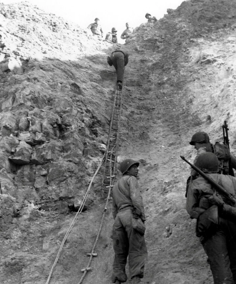
After duck boats, grappling hooks, and rope ladders initially failed, the Rangers found a small area of the beach where the cliff had partially collapsed and left a pile of rubble at the bottom. This cut their straight vertical climbing distance in half. They then stabbed their knives into the cliff face to use as hand/foot holds and tediously made their way to the top around 7:30 a.m. Rangers arriving a little later were able to establish rope ladders. They discovered the casemates and concrete platforms behind the observation bunker were empty: the Germans had moved the guns. They moved further inland to a road and set up a roadblock at about 8:15 a.m. They continued to search, located the guns along the road in an apple orchard about 0.8 miles from the original positions, and destroyed them with grenades by 9:00 a.m. In the process, two Rangers tossed a grenade into a large casemate they thought contained a gun. But it was actually the German’s ammo supply bunker. The subsequent explosion killed all 10 German soldiers inside, injured the two Rangers, and blew the heavy bunker apart. The roof of the bunker was fractured into 5-6 pieces, with each piece variably tossed 10-80 feet away. Today these pieces remain where they fell on D-Day.
Pointe du Hoc in 1944. Top left: rubble and cliffs where initial climb was made. Top right: Rope ladder being used up the side of the cliff. Bottom left: Orchard south of the road where the coastal battery guns were found. Bottom center: An officer stands at the bottom of a bomb crater. Bottom right: one of the empty gun casemates.
Right: two large pieces of the ammo bunker roof on the west side of the main gravel road, about 10-20 feet from the original position of the bunker. Left: two smaller pieces of the ammo bunker roof on the east side of the main gravel road, about 80 feet from the original position of the bunker, and laying on the rim of a large bomb crater.
After the guns were destroyed, the Rangers continued to encounter German resistance. They requested reinforcements, but the Allied commanders denied the request; the dedicated reinforcements had already been re-vectored to the east and no other units could get to Pointe du Hoc due to heavy fighting at Vierville and Colleville. They held their position and managed to repel three German counterattacks, despite consistent heavy losses. On 8 Jun, with only 40% of their original number remaining (90 of 225), they were finally relieved.
Epic story; truly the stuff of Ranger legend, but… what about the good ol’ fashioned and fiercely indiscriminate carpet bombing?!?! Why was Pointe du Hoc not sent into oblivion with extreme prejudice around 7:20 a.m. like Allied commanders intended?? Guillaume told us that shortly after arriving at Pointe du Hoc, the Rangers ran into a small contingent of Airborne troops that had been misdropped into the Omaha sector earlier that morning (Pointe du Hoc divides Omaha and Utah, more on Utah and the Airborne side of this odyssey later). One of these paratroopers happened to pack an American flag in his rucksack. They posted this flag on the cliff face before they scaled it to ward off friendly fire from the AAF & Navy. It apparently worked like a charm.

American soldiers escort German prisoners of war down the side of Pointe du Hoc where an American flag is affixed to the cliffside.
Leaving Omaha
By this time in the tour, it was about 1:00 p.m. and we were all very hungry. Guillaume assured us our next stop included time for lunch with lots of good restaurant options. With that promise, we enjoyed a 30-minute break from walking and standing in the heat as we drove into the Utah sector.
Whew… holy smokes, if you read this whole thing, I’m super proud of you 😆. Fun closing fact: this post has 4,650 words & 27,629 characters. I hope you learned something along the way. Other interesting things I came across in my Omaha research are linked below.
USS Texas at Omaha (13 mins): https://www.youtube.com/watch?v=J9IabP_W3SM&t=119s
Pointe du Hoc Ranger's recorded memoir: George Kerchner (9 mins): https://www.britannica.com/place/Omaha-Beach/Pointe-du-Hoc#/media/1/428201/40571.
Tango Sierra out!








Comments